
The effectiveness of NBS to reduce pluvial flooding risks in Eindhoven
- Thu, 30/01/2020
As well as climate change, urban sprawl poses a number of challenges to city management and planning. Recent studies suggest a likely intensification of rainfall and hydrological regimes, with the increased probability of extreme rainfall events and associated flash flooding (Bates et al., 2008). Urbanisation aggravates flood risk by increasing impermeable surface areas and altering water’s flow paths. The combination of these land-cover and climate changes are expected to make urban areas more vulnerable to pluvial flooding (Willems et al., 2012).
Like many other cities, Eindhoven in the Netherlands suffered from urban expansion that was not accompanied by adequate upgrades to sewer and storm water networks. This has led to an increase in urban flooding, consequential property and infrastructure damage and associated costs (Sušnik et al., 2014). To counter this, the Eindhoven municipality has developed various near future (NBS2015) and future (Future NBS) adaptation measures that foresee the implementation of certain nature-based solutions (NBS) to reduce pluvial flooding. Near future NBS include river daylighting and the requalification of green spaces, while future NBS include green parking spaces, green roofs and street water storage. These different scenarios can be seen in Table 1.
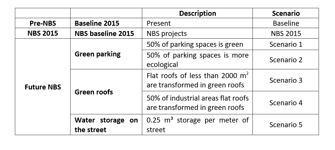 Table 1: Scenarios overview
This study analysed the effectiveness of the future NBS to reduce urban flooding, focusing on the flooding area, flood depth and flood velocity. To this end, hydraulic simulations were performed with the coupled 1D/2D numerical model developed by Innovyze (2012), using the software package Infoworks. These simulations were performed for the baseline, the NBS2015 and Future NBS scenarios, and involved rainfall events with 5, 10 and 100-year return periods. Sewer flow was represented by full 1D Saint Venant equations, while surface flow in the form of overland flow on streets, and other pervious and impervious areas was simulated by full 2D Saint Venant equations. The simulations furthermore included flow exchanges between manholes and the cells of the mesh.
Geographical Information Systems (GIS) were then used to examine the simulation results for street flooding in each scenario. The results showed a decrease in the flooding area in most of the future scenarios. Scenario 3 resulted in the largest decrease in the flooding area (Figure 1). This scenario also had the greatest impact at the scale of individual neighborhoods, with the lowest number of neighborhoods being flooded by more than 10% of their surface area. In contrast, the NBS 2015 scenario saw an increase in the flooding area as predicted, which can be explained by the daylighting of the Gender river.
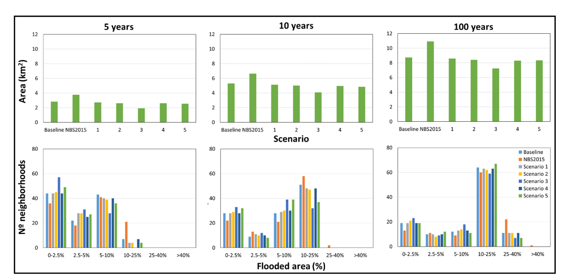
Figure 1: Flooding area for the Baseline, NBS2015 and Future NBS scenarios for 5, 10 and 100-years return periods.
Predicted average flood depth and velocity showed somewhat different results, as scenarios 3 and (to an extent) 2, lead to a decrease in flood depth in most simulations (Figure 2). Only NBS2015 and scenario 3 lead to a decrease in flood velocity (Figure 3).
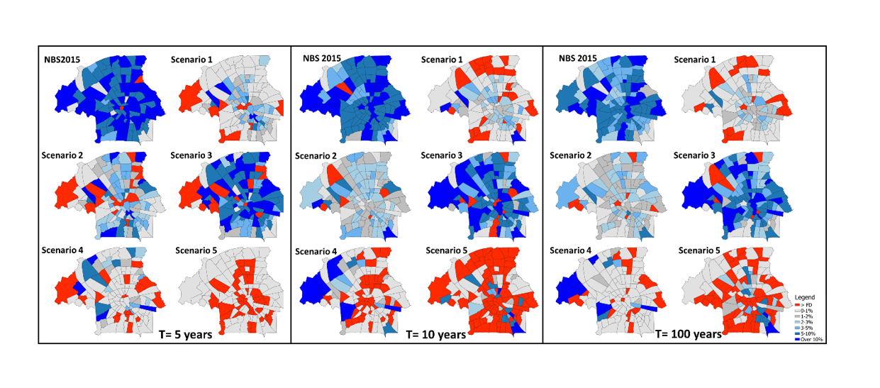
Figure 2: Differences in flood depth compared to baseline conditions for 5, 10 and 100-years return periods.
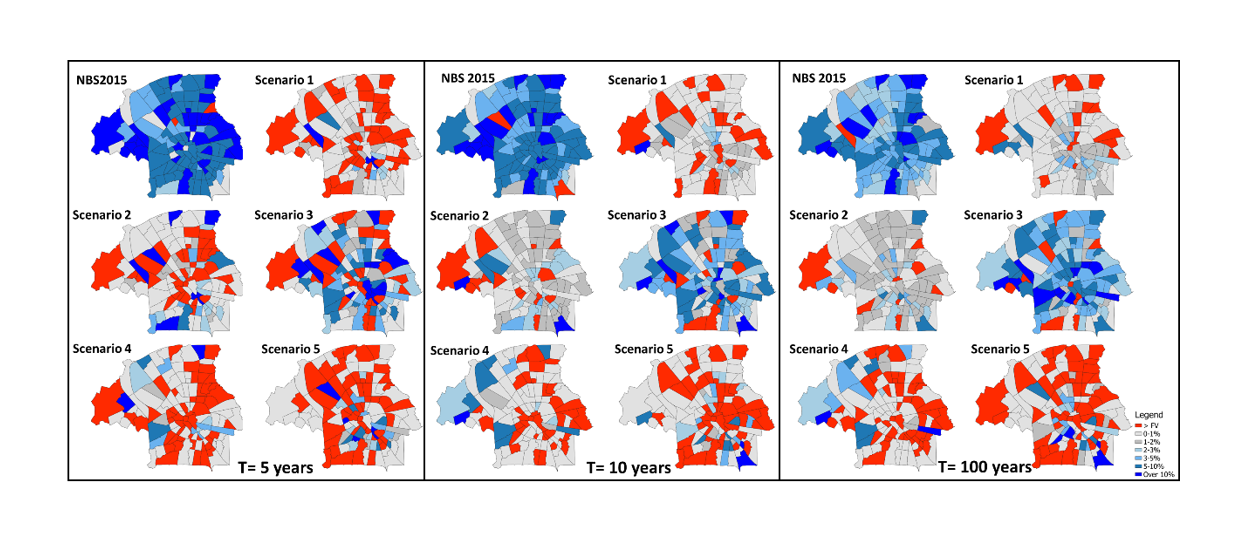
Figure 3: Differences in flood velocity compared to baseline conditions for 5, 10 and 100-years return periods.
These results reinforce those of previous studies, in that NBS can have clear benefits in reducing flood risk and should be duly contemplated when designing strategies for resilient flood risk management. This study’s results suggest that combinations of different NBS can allow for maximum effectiveness across rainfall events with growing return periods.
This article was written by Costa, S (1), Peters, R. (2), Martins, R. (1), Postmes, L.A. (2), Keizer, J. (1) and Roebeling, P. (1 & 3).
1 Centre for Environmental and Maritime Studies (CESAM) & Department of Environment and Planning, University of Aveiro, Portugal
2 Green and Water Department, Municipality of Eindhoven, Eindhoven, The Netherlands
3 Wageningen Economic Research, Wageningen University and Research, Wageningen, The Netherlands
References
Bates, B., Kundzewicz, Z., Palutikof, J., Wu, S. (2008). Climate Change and Water: Technical Paper of the Intergovernmental Panel on Climate Change. Intergovernmental Panel on Climate Change, Geneva Available from: https://www.ipcc.ch/pdf/technical-papers/climate-change-water-en.pdf.
Sušnik, J., Strehl, C., Postmes, L., Vamvakeridou-Lyroudia, L., Mälzer, H.-J., Savić, D., Kapelan, Z. (2015). Assessing Financial Loss due to Pluvial Flooding and the Efficacy of Risk-Reduction Measures in the Residential Property Sector. Water Resources Manage, 29(1): 161-179.
Willems, P., Olsson, J., Arnbjerg-Nielsen, K., Beecham, S., Pathirana, A., Gregersen, I. B., Madsen, H., Nguyen, V.-T.-V. (2012). Impacts of Climate Change on Rainfall Extremes and Urban Drainage. IWA Publishing, London, UK.